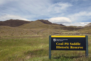
Located in the Gibbston Valley between Cromwell and Arrow Junction, Coal Pit Road runs South from SH6 into the hills East of the Remarkables. Coal Pit Road is more dirt track and has several washouts that are fairly easy, though the last one is deep with only a narrow track on each side in spots.
Several tracks carry on from where this GPS track log ends at the Saddle, one continues into The Nevis Valley while another apaprently joins up with the The Nevis Valley track. Local 4wd’ers have said its fairly straightforward to continue on but a motorcyclist has said it’s fairly involved. Either way there is plenty more exploring to do further on from the end of the current recorded track.
This entire area is very remote with little traffic and no cell phone signal. It’s recommended you either don’t tackle these tracks alone or carry a Personal Locator Beacon, and make sure someone knows where you are going. Coal Pit Road can also be very exposed and have alpine conditions. This means temperatures and weather conditions can change quickly and riders should be prepared for heat and cold.
If you are up Coal Pit Road post some pictures, and if you go further in send in an updated GPS tracklog.
Contributed by: @martin_worswick
Track type: Dirt Track
Track composition: Rough, Loose, Steep
Slippery when wet? Yes
Suitable for bikes <650cc? Intermediate
Suitable for bikes >650cc? Experienced
River crossings? No