WP GPX Maps Error: GPX file not found! /home/adventur/public_html/wp-content/uploads/gpx/Taylor_Pass_250.gpx
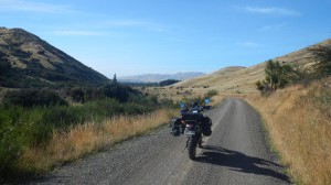
Looking South on Taylor Pass Road
Taylor Pass offers an alternative route into/out of the top of the Awatere Valley/Molesworth Station. Running from the Blenheim suburbs the well tended gravel road takes you over a range of hills and comes out at the top of the Awatere Valley, neatly avoiding the traffic and boredom of SH1.
Contributed by: @eddieb
Track type: Gravel Road
Track composition: Smooth, Firm, Undulating
Slippery when wet?: Yes
Suitable for bikes <650cc? Beginner
Suitable for bikes >650cc? Beginner
River crossings? No
Invalid download ID.
The 29 second mark to the 50 second mark of this video shows a short section of Taylor Pass.
Subscribe
Login
5 Comments