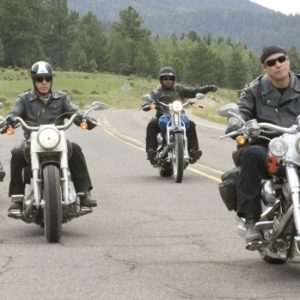
Adventure Riding from North to South Island in 8 Days
17th Sep 2013, Tue (Before starting the Journey)
We went for a ride up to Mount Eden, Auckland after getting Sertao BMW bike and we were just in time for sunset.
Frank with bike
Mei with the bike
Day 1 – 18th Sep 2013, Wed (from Auckland to Tongariro National Park)
It was an exceptional sunny day for a good start of bike riding. After breakfast at Olaf Restaurant, Mount Eden, Auckland we started our adventure riding at 1030am. From Auckland, we took state highway 1 towards Hamilton. We were looking for Highway 22 route on the way. It took us quite some time to find out before giving up. We asked for direction at petrol station and we were lucky to meet friendly bikers to show us the direction. We started the off road riding at Pukekohe.
Picture of us on the bike
We found the Highway 22
Greenery Mountains along Highway 22
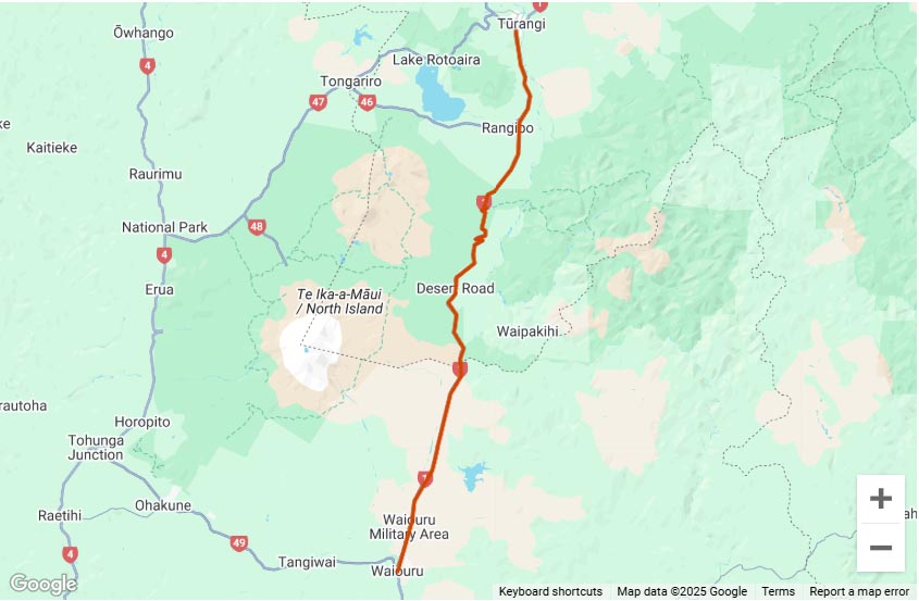
Highway 22 is indeed a recommended unsung scenic route to explore the true beauty of North Island. There is about 30km of adventurous gravel road in the journey. It was a slow and careful ride due to the bad surface, full of potholes and animals’ crossing. From highway 22, it leads back to main road and heading towards Tongariro National Park. Mount Ruapehu is looming in front of us as we were approaching the destination. The total journey takes about 435km and 9 hours of ride included breaks in between. It gets darker and colder as we reached at destination at 7pm. We were totally exhausted after this ride due to the weather. We checked in Plateu Lodge for a good rest. Following is the route map:
Day 2 – 19th Sep 2013, Wed (from Tongariro National Park to New Plymouth)
At 730am, we continued our journey after packing. It was a cloudy day. We took Forgotten World Highway towards New Plymouth. 12km of the highway is unsealed road and there is no petrol station on the way. Therefore we filled up the tank before moving. The total 155km of adventure begins at Taumarunui and ends at Stratford. It follows ancient Maori trade routes and pioneering farm tracks, through ambitious historic settlements, untamed native bush and stunning natural scenery.
Whakapapa River on the way towards New Plymouth
Group picture
Scenery along Forgotten World Highway
On the way, there is a detour along Moki Road leads to a 20 minutes walk to Mt Damper Falls. It is the North Island’s second highest waterfall and is the spectacular sight. Shortly after that, there is a single lane 180m long Moki Tunnel that was built in 1936 and is known locally as the Hobbit’s Hole.
The Hobbit’s Hole
From Forgotten World Highway, it merges to state highway towards New Plymouth. On the way, we stopped at White Cliff for a short break.
Panoramic view of White Cliff with wheel prints of 4WD on the right
Walkway map at the entrance of White Cliff
The whole journey took about 380km and 6 hours to reach at destination. It was a heavy downpour when we reached at 6pm. We were lucky to have checked in Duck and Drakes Lodge by then. Following is the route map of Forgotten World Highway from Taumarunui to Stratford:
Day 3 – 20th Sep 2013, Thu (from New Plymouth to Wellington)
We departed at 9am for another 350km journey down to Wellington. When we left New Plymouth, it was foggy on the road. We have difficult vision and missed out some of the great views on the way such as Mount Taranaki. However, the sky clears up in the afternoon. We were riding along the coastal route, taking state highway 3 towards Wellington passing Opunake and Wanganui on the way. We stopped at Wainui Beach for a break.
Panoramic view of Wainui Beach
It was an easy ride and took us about 6 hours to reach at destination. It was windy and heavy downpour in Wellington as we reached. We checked in Kingsgate Hotel at 7pm. Following is the route map:
Day 4 – 21st Sep 2013, Fri (From Wellington to Kaikoura)
We left the accommodation at 8am to catch ferry Interislander at 830am. It was drizzling in the morning. We checked in the bike at Deck 3 then chilled out at Deck 7.
Vehicle Check-in stop
Interislander view on the way to car park at Deck 3
Secure tie down of the bike which took nearly 30 min
Directory of Interislander
There are lounges around which allow passengers to have rest and to dine while enjoying the views outside the ferry. It passes through Marborough Sound but it was a bad weather therefore vague visibility to behold the magnificent view around the islands. The journey took about 2 hours from Wellington to Picton.
Approaching Picton Wharf
After checking out the bike, we continued our journey and drove past Blenheim through state highway 1. It was a sunny day for a good start in South island. We stopped at Half Moon Bay for pictures.
Half Moon Bay
It took about 5 hours from Picton to Kaikoura. At about 6pm, we reached and checked in Dolphin Lodge.
View from Balcony at Dolphin Lodge
Before night falls, we had a stroll along Kaikoura Peninsular and a walk around Kaikoura town center then discovered that there is a vintage car rally.
Day 5 – 22nd Sep 2013, Sat (From Kaikoura to Christchurch)
We departed to Christchurch at 10am and no back road this time. We drove past Cheviot and Waipara along the shoreline. We reached about 6pm just in time before the rain started. We checked in Jailhouse Lodge. This lodge used to be a female prison, which was built because of the overcrowding at Lyttelton.
Jailhouse accommodation at the entrance
View of the accommodation from top
Day 6 – 23rd Sep 2013, Sun (From Christchurch to Queenstown)
It was a great day to continue to the last town before heading to Milford Sound. We spent about 2 hours on bike service before continuing as it reaches about 1500km by then. From Christchurch, we drove down to Rangitata then taking highway 79 passing Geraldine towards Lake Tekapo.
Great view on the way to Lake Tekapo
Lake Tekapo is located at 42km west of Fairlie, with an altitude of 710m. The most striking thing about Lake Tekapo is its extraordinary colour in which the light reflected from microscopic rock particles suspended in glacial meltwater lends the water an ethereal opaque-aqua hue. We stopped at the well-known Church of the Good Shepherd, an enchanting little stone church built in 1935 as a memorial to the Mackenzie Country pioneers.
Church of the Good Shepherd
Magnificent view to behold at Lake Tekapo
We also photographed the Collie Dog Monument that is about 100m to the east of the church. It was erected in 1968 by local sheep farmers to honour the dogs that make it possible to graze this harsh terrain. We reached at Lake Pukaki after about 20min from Lake Tekapo. It is just located next to each other but it is an unsung destination with no sign of tourist.
Panoramic view at Lake Pukaki
From there we continued towards Twizel and Omarama then Lindis Pass. It was getting dark as we arrived in Wanaka and had a break at Lake Wanaka for sunset.
Lake Wanaka at sunset
Wild ducks around the lake
From there we drove towards Queenstown through the back road. It was about 8pm when we reached at A-Line Heartland Hotel.
Day 7 – 24th Sep 2013, Mon (Queenstown)
We stayed another one more night in Queenstown to explore further. We had breakfast at Post Office Café.
Breakfast at Post Office Cafe
After that, the first stop is Glenorchy, at the head of Lake Wakatipu 50km northwest of Queenstown. The scenic drive along Lake Wakatipu takes about 30km to The Wharf Shed. The lakeside drive passes Bob’s Cove, the best place to observe the lake’s seiche, a phenomenon which causes the lake level to fluctuate by around 150mm every five minutes.
Ducks and birds at Steamer Wharf
TSS Earnslaw Steamboat
The whole journey along the lakeside drive takes about 30minutes to reach The Wharf shed. The shed is originally built by NZ railway department as a goods shed for freight carried on the steamers between Queenstown and Glenorchy. There is a well-trained dog ready to play with tourists around the shed. The dog is smart to understand human, as it would play until you bid farewell. We manage to relax at the abandoned wharf under the sun. Then we proceeded to Moke Lake. The access is along the way but the it is about 20km gravel road.
Lookout at Glenorchy scenic drive
View to the right at Glenorchy lookout
On the way towards Moke Lake
Moke Lake
We were in Arrowtown for sunset. The town still has the feel of an old gold town and retains the spirit of a living community with grocers’ shops, pubs and post office. After the short walk in Arrowtown, we proceeded for a dinner at Skyline by Gondola.
The main street in Arrowtown
Directory of Arrowtown
one of the café in Arrowtown
Entrance to gondola of Skyline
Night view of Queenstown from gondola
Gondola to Skyline
Day 8 – 25th Sep 2013, Tue (From Queenstown to Milford Sound)
From Queenstown, we took the steamboat, TSS Earnslaw to transport the bike across Lake Wakatipu to historic working station of Walter Peak. TSS Earnslaw is a magnificent vintage steamship believed to be the only coal-fired passenger- carrying vessel still operating in the southern hemisphere.
Loading bike in Steamboat
Lake Wakatipu
View from the top of steamboat
Reaching at Walter Peak Station
Unloading bike with one panel detached due to the limited space of sliding path
Re-atttaching panel back in position
View of steamboat from Walter Peak Station
From there we continued on the Mount Nicholas gravel back-country road along the Western Shores of Lake Wakatipu with few ups and downs all the way through to Mavora Lake with 2 river crossings. There is no other food or drink along the way or petrol station. 20km after the second river crossing, we reached at Mavora Lake where we had a break.
Mount Nicholas road at the back country
First river crossing
Scenery on the way
Second river crossing before beginning
Second river crossing
Mavora Lake
Then we continued our journey towards Te Anau after Mavora Lake on state highway that took us about 30minutes of ride. It was about 6pm when we reached at Te Anau and had a break at Pop In Café next to Te Anau Lake.
View from Pop In Café to Te Anau Lake
The journey towards Milford Sound from Te Anau took us another 1 hour of ride. It is a scenic route along the way through Homer Tunnel passes Mirror Lake, the Chasm, Milford Sound National Park and water falls.
Milford Sound eventually
Finally, the adventurous riding ended at 730pm at Southern Discoveries accommodation!